Alcazar of SegoviaAlcazar, a castle-palace, lies in the walled city of Segovia in the province of Segovia in Spain. It's one of the most famous castles in Spain due to the fact that a lot of Spanish kings resided here and because of its beautiful exterior. The construction of this majestic castle-palace probably began in the last quarter of the 11th century, by King Alfonso VI, following the Reconquest, on a site fortified by the Romans, Visigoths and Moors successively. The great keep, with its dozen semicircular sentry boxes, next to the entrance of the Alcazar over the artificial moat (seen left), was the last to be built. A lot of royals resided here, such as; King Ferdinand III, King Alfonso X, King Juan II and King Enrique IV, who all altered the buildings to their likings.Building History:Originally a fortress, the Alcázar has also been a royal palace, the site of Philip II's wedding to his fourth wife, Anne of Austria, and more recently a military academy. In the upper part of the city, the oldest foundations have been identified as Roman. Documents indicate that a fortress existed on this site by the early 12th century known as the Alcázar, an Arabic word for a royal residence. The palace was enlarged in the 13th and 14th centuries and again during the reign of King John II (1405-1454) when towers were added and the East Tower and moat were enlarged. Under Philip II (1558-1598) major alterations were made; slate roofs and spires on towers were added. From 1764-1862 the Royal Artillery College was housed here.
 During John II's reign the East Tower was enlarged; now called the Tower of John II, it is twice as high as the original (which came to the line of balls across the center, halfway up) and twice as wide. The double horseshoe window, which dates from the 13th century, was one in the center of the tower. Bars on the windows reveal this tower's history as a state prison.
Patio de Armas, designed by Francisco de Mora, 1593 A medieval courtyard, the doorways of which remain, had once provided an open space in the center of the residential part of the palace. During the reign of Philip II (1556-1598) a number of alterations were made, including the design of this parade ground, in the style of the Escorial. (Francisco de Mora was Juan de Herrera's student.) This elegant Renaissance courtyard has two storeys in granite with semi-circular arches on the first floor and a post and lintel structure on the second. Galleries are on three sides of the courtyard, which has a stone fountain at the center.
In 1862 however the Alcazar was devastated by fire. In 1882, it was rebuilt using old sketches of the interior before the fire. It see inside today is a 19th century remake. After completion the Alcazar firstly became the Military Archives and later an Artillery Academy and Museum. In the mid-20th century this use also ended and the Alcazar is now used for cultural activities and as a museum. It's state-owned. Visitors can climb the keep for some great views.
The Moat
 The defensive moat goes back to the middle ages although the arcade spanning it dates from the 16th century. At 26 meters down, it was crossed by a drawbridge at the front of the palace.Here some views of Alcazar of Segovia:The Outer Hall
 The Throne Room
 The Galley Room, which gets its name from the shape of the ceiling being like an inverted hull of a ship.
Stained class window in Alcazar


The Pine-Cone Room
 Queen of Castille
 The Royal Bedroom
 The Room of the Monarchs

 The frieze bordering the room has figures of all
the monarchs of Asturias, Castile, and Leon.
The Chapel
The Armory

16th century hunting crossbow Minting coins from the 18th century
The Museum of the Royal Artillery School
Arches National ParkArches National Park is a U.S. national park in eastern Utah. It established as a National monument in 1929, and as a National Park in 1971. Arches National Park as know as contains one of the largest concentrations of natural sandstone arches in the world. It's land area is about 73,379 acres (297 square kilometer).Before thousands of years, Archaic people, and later ancestral Puebloan, Fremont and Utes searched the arid desert for game animals, wild plant foods and stone for tools and weapons. They also left evidence of their passing on a few pictograph and petroglyph panels. The ancestral Pueblo and the Fremont Indians left the area about 700 years ago. As the ancestral Puebloan and Fremont peoples, such as the Ute and Paiute, entered the area, they were here to meet the first Europeans in 1776. The petroglyph panel near Wolfe Ranch is believed to have some Ute images since it shows people on horseback, and horses were adopted by the Utes only after they were introduced by the Spanish.Produce of Natural Arch:Natural arch or natural bridge is a natural formation where a rock arch forms, with a natural passageway through underneath. Natural arches commonly form where cliffs are subject to erosion from the sea, rivers or weathering. The processes "find" weaknesses in rocks and work on them, making them bigger until they break through.Arches National Park in over millions of years, the salt bed underneath was no match for the heavy layer of rock. Under the pressure of the rock, the salt layer shifted, buckled, and liquified, thrusting the layers upwards. Faults deep in the Earth caused movement that produced vertical cracks in the stone. Surface erosion stripped away the younger rock layers while, over time, water seeped into the long, straight cracks. Erosion along the straight cracks shaped the sandstone into slender, upright slabs of rock resembling walls. The slabs, when exposed on the surface are called "fins."
 Once the faces of the fins are exposed, erosion begins to act here too. In the winter, water turns to ice putting pressure on the surrounding rock, breaking off bits and pieces. Wind and water attack the standing fins of rock and, in some, the cementing material gives way. Chuncks of rocks tumbled down. Many fins collapse, but some are strong enough to remain standing, becoming the famous arches.Famous Aches and Sandstones in Arches National Park:Landscape Arch
 Landscape Arch to be the longest natural arch in the world, it is a staggering 290 feet long (almost a football field) and is as thin as 6 feet. In the past visitor could hike under the arch, but massive rock falls in 1991 and 1995 have forced the park service to close off access to the area.Wall ArchIts collapse in August 4, 2008. Before that, it was ranked 12th in size among the park's over 2,000 arches. It had 71 feet wide by 33 and half feet high.Before collapse
 After collapse
 Delicate Arch
 Delicate Arch is a 52 ft (16 m) tall freestanding natural arch. It is the most widely-recognized landmark in Arches National Park. Beside, its also the symbol for Arches National Park.Balanced Rock
 Balanced Rock is another one of the most popular features of Arches National Park. Balanced Rock is located next to the park's main road, at about 14.5 km from the park entrance. The total height of Balanced Rock is about 39 m, with the balanced rock rising 16.75 m above the base. Balanced rock named "Chip Off The Old Block", which fell during the winter of 1975/1976.Skyline Arch
 Sand Dune Arch
 Cove Arch
 Broken Arch
 Double Arch
 Double O Arch
 Devils Garden
 The Windows
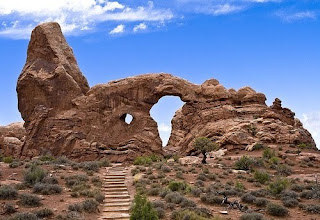
 Tower Arch
 CourthouseTower
 Park Avenue
 Turret arch
 Parade of Elephant
 Tunnel Arch
 Pine Tree Arch
 Navajo Arch
 Dark Angel sandstone
Machu Picchu
Machu Picchu are one of the most beautiful and enigmatic ancient sites in the world. It built during the 1460 and 1470 AD in the Andes Mountains in Peru by classical Inca style(Dry Stone). Machu Picchu referred to as "The Lost City of the Incas", it rediscovered in 1911.Inca Wall The Incas started building it around AD 1430 but was abandoned as an official site for the Inca rulers a hundred years later at the time of the Spanish conquest of the Inca Empire. Although known locally, it was largely unknown to the outside world before being brought to international attention in 1911 by Hiram Bingham(an American archaeologist). Since then, Machu Picchu has become an important tourist attraction.Intihuatana:The Intihuatana (also called the Saywa or Sukhanka stone) is meaning 'Hitching Post of the Sun'. It is an intriguing carved rock whose shape mimics that of Huayna Picchu, the sacred peak rising beyond the ruins. Though the Incas created rocks like this for all their important ritual centers, Intihuatana is one of the few not destroyed by the Spanish Conquistadores.
 Wayna Picchu:
Wayna Picchu also called as Huayna Picchu is a mountain in Peru around which the Urumbamba River bends.Incas built a trail up the side of the Huayna Picchu and built temples and terraces on its top. The peak of Huayna Picchu is about 2,720 metres above sea level, or about 360 metres higher than Machu Picchu. The top of the mountain was the residence for the high priest and the local virgins. Every morning before sunrise, the high priest with a small group would walk to Machu Picchu to signal the coming of the new day.Three temples in Machu PicchuTemple of Sun:The Temple of the Sun was used to honor and celebrate Inti, the Sun, an important Incan deity. When the sun of the winter solstice enters through the central window, it falls directly on the large ceremonial stone. The round building protects the stone. Temple of Moon:The Temple covers the entire landscape of the slopes of Huayna Picchu and consists of a set of architecturally enhanced caves, most likely used to hold mummies of important Inca ancestors and provide places for their worship. More fine stonework embellishes the walls of these caves, some of which are decorated with niches and altars carved into the native rock.
 Temple of Condor:The temple of condor is a breathtaking example of Inca stonemasonry. A natural rock formation began to take shape millions of years ago and the Inca skillfully shaped the rock into the outspread wings of a condor in flight. On the floor of the temple is a rock carved in the shape of the condor's head and neck feathers, completing the figure of a three-dimensional bird.
 Here the good view of Machu Picchu:


